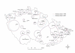
Two situations (as of 1900 and 2001) representing the spheres of influence (tributary areas) of the Czech settlements (with more than 25.000 inhabitants in 2001) are compared in the figure. The intention is to present the possible application of the spatial interaction modelling in historical geography. Figure captures the 20th century development of the Czech settlement system and its historical driving forces, such as for instance industrial location (Bata´s Zlín), expulsion of Germans after WWII (the Czech borderland). On the contrary the general stability of the Czech settlement system during 100 years is witnessed as well. The need for a correct interpretation of the model based on historical knowledge is clearly documented in the figure.
Figure source: Řehák, S., Halás, M., Klapka, P. (2009): Několik poznámek k možnostem aplikace Reillyho modelu [Several notes on the possibilities of the application of the Reilly´s model]. Geographia Moravica 1. UP v Olomouci, Olomouc, 47 – 58.
